|
Alabama
California
Colorado
Connecticut
Georgia
Kentucky
Maryland
Massachusetts
New Hampshire
New York
North
Carolina
Pennsylvania
South
Carolina
Tennessee
Virginia
West
Virginia
|
|
Garmin GPSMap 60CSx Handheld GPS Review
|
|
Background: In my younger years I would take off on a trail with no
real concern as to it's destination or how well it was blazed. Looking
back I can see that being young is no excuse for being stupid. These
days my hiking party includes my wife and my 2 year old daughter. I Do
Not want to get lost. A few weeks ago we went hiking in the Hanging Dog
Recreation Area near Murphy, North Carolina. We live a few miles from
the area and thought this would be an easy area to hike. The trails
there are in great shape, but every half mile or so you come across a 2
or 3 way split in the trail. The splits are all marked, but unfortunately
it's the same trail. My goal is 1) not get lost this close to home 2)
map out the trails in the area so others (and myself) will have an
easier
time. I should point out that I have never used a GPS unit of any type
so this review will be ongoing for some time.
Review: The Garmin GPSMap 60CSx is small, light and comfortable
to hold. The first time I turned the unit on it had my position within
25 feet in less than 3 minutes. By the end of the 4th minute my position
was within 17 feet or so. By the way I should mention that I was sitting
in my house during this time.
|
|

|
|
Garmin GPSMap 60CSx
From Garmin:
- High-sensitivity GPS
receiver gives you improved satellite
reception even in heavy tree cover or deep
canyons
- Barometric altimeter
provides extremely accurate elevation data
- Electronic compass can
determine your heading and direction, even
when you're standing still
- IPX7 waterproof case can
withstand an accidental dunk in the water
and still perform
- Large, color TFT display
makes viewing the screen easy, day or night
- Built-in Americas autoroute
basemap, including highways, exits and tide
data, gives you automatic, turn-by-turn
directions
The 60CSx comes with a blank
64 megabyte (MB) microSD card, so you can store
extra maps from optional MapSourse® mapping
software. Just connect to your computer with the
USB card, and you can load map data or transfer
routes and waypoints. |
|
|
|
|
The instruction book was clear (for the most part) and
had me up and running in no time. One feature I found very helpful while
sitting in my house was the fact that the included USB allowed my laptop
to power the unit. This also keeps the backlight on non-stop which
really helped in my low-light living room. I thought I would have to go
through a long setup, but putting in batteries and pushing the on button
was it. Ok my elevation was off by about 7 feet.
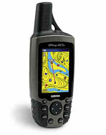
With my Garmin GPSMap 60CSx, I also received
the Garmin TOPO U.S. 2008. This mapping program is great, I was side
tracked for a couple of hours playing. I selected the area from the TOPO
which I wanted to hike and loaded the 60CSx (takes less than a minute).
As I was hiking the maze of trails at Hanging Dog, I was constantly reassured
by the fact that I could always backtrack and by the fact that the unit
showed the nearby lake, boat ramp, the paved road, and campground ( the
TOPO map included these). Having this knowledge gave me a general idea
of my location and since my 2 year old has a max range of about 2 miles.
The Garmin GPSMap 60CSx gave us a constant
readout of the distance traveled, time moving, time standing
still, altitude, total accent, latitude/longitude, while showing
a visible track of our hike.
Having completed our first hike with the 60CSx,
I now have my first mapped out loop at Hanging Dog Recreation
Area. After returning home I loaded the recorded 2.7 mile track
to my computer. With only 6 miles or so of trails in the area
remaining we are well on our way to mapping out the trails.
To be continued...
|
|
|


Gatlinburg,
Pigeon Forge Cabin Rentals

|